
|
Photography Outdoors |
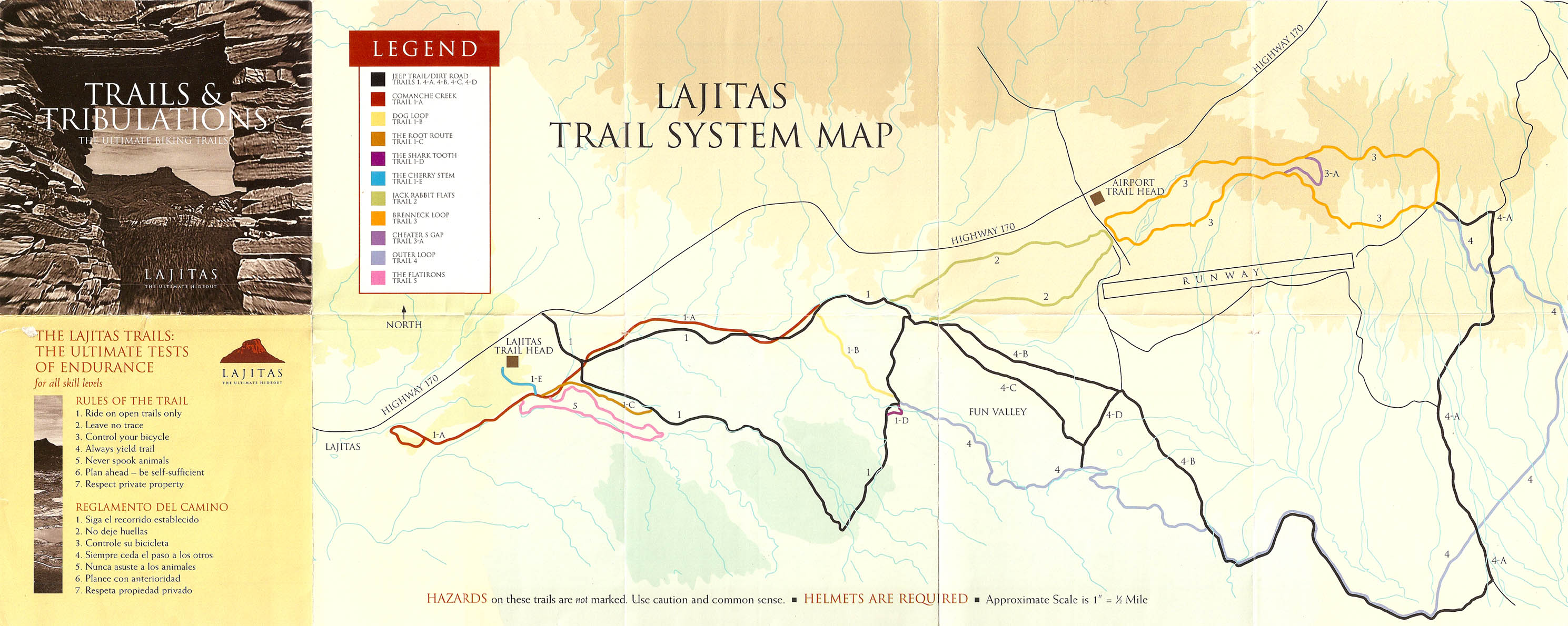
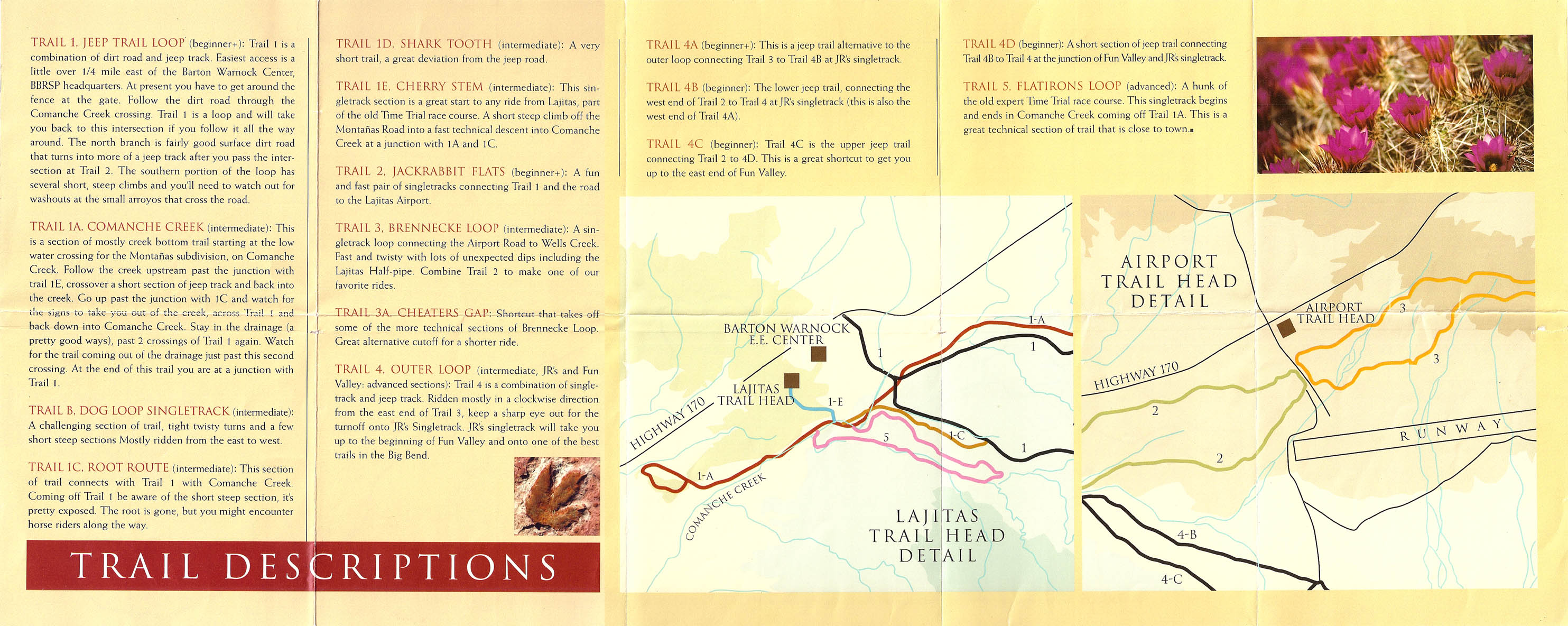
Lajitas TrailsGPS Tracks: GPX format, KMZ format The Lajitas Trails comprise more than 30 miles of singletrack and doubletrack trails in the desert near Lajitas, Texas, a small resort town on the Rio Grande between Big Bend National Park and Big Bend Ranch State Park. The trail network is bounded roughly by the Mesa de Anguila to the south, F. M. 170 to the north, the town of Lajitas to the west, and the "Lajitas International Airport" to the east. A color coded map of the trail system can be obtained from Desert Sports, an outdoor outfitter located on the north side of F. M. 170 in Terlingua. Desert Sports is instrumental in maintaining and building mountain biking trails in the area. The most popular way to access the trail network is from the Lajitas Airport. Since this airport is no longer open full time, a trailhead and parking area have been created just outside the airport gates next to the highway. Park at the trailhead kiosk rather than on the airport grounds, because if you park inside the airport gates, you might get locked in. In general, the Lajitas trails are all on desert terrain with a composition of hard-packed dirt or crushed sandstone. There are few large rocks. Most of the technical obstacles are short, steep climbs and drops over hills, washed out sections, a handful of sand traps, an occasional off-camber or mildly exposed section, and arroyo crossings (some of which are so sharp and narrow that intermediate skill is required to negotiate them without endoing.) The trails are, in places, very faint or a bit overgrown due to underuse. Trail markers are only located at trail intersections, and there are a few intersections that aren't on the map. In general, it's very easy to get lost out there, so pay attention to where you're going. A GPS is strongly recommended. There are 15 separate trails in the network: 1 = easy doubletrack As of this writing, Desert Sports reports that the loops nearest Lajitas, including 5 and 1A, are no longer being maintained, but the airport trails are still active. The "intermediate" trails are rated mainly for their distance and for a handful of intermediate level obstacles, but in general, these trails are mostly fast, flat, smooth desert singletrack -- about 95% green and 5% blue. They should be very accessible to less technical riders. Starting at the airport, you can make a good 16-mile singletrack loop by riding the north half of Trail 3, all of Trail 4, Trail 1B, then connecting back to the north half of Trail 2 via Trail 1. You can make a shorter loop by riding all of Trail 3, then all of Trail 2. As you ride out on the north half of Trail 3 from the airport, be extra cautious of the section at the eastern end of the airport, where Trail 3 follows along a dry creek bed. The exit onto the south half of Trail 3 is on the right (west side) of the creekbed, followed by the exit onto Trail 4 on the left (east side) of the creekbed. Once on Trail 4, you will cross 4A (a jeep road) twice before joining the jeep road and following it for a couple of miles. There is an unmarked jeep road intersection in here, at which one road bears left onto the mesa and another bears right. The left-hand road is marked with an "X". Don't take that road. Bear right instead onto 4B. Watch for a place along 4B where the Trail 4 singletrack diverts from the jeep road and goes up a rise to the left. This section of Trail 4 is called "JR's Singletrack." At the next intersection, bear left again onto "Fun Valley" (still Trail 4.) JR's and Fun Valley are much more deserving of their intermediate rating and contain some good grinding climbs, mild exposure, a few rocky sections, and some off-camber stuff. At the next junction, bear straight onto 1B, another fun little section of singletrack. Turn right onto Trail 1 (jeep road), which follows a dry creek bed for a short distance before climbing out the other side. There is a weird intersection where Trail 1 and Trail 2 meet. If you keep going straight on the jeep road, you end up on an unmarked road that dead ends at the highway. Look for the Trail 2 sign on the right (the map makes it look like the turnoff should be to the left, but it's not.) Trail 2 is an easy ride back to the airport road. |